I got an early start - away from the dock at around 7:30 AM Saturday morning. After hearing Alan talking about the facilities at Suffolk I thought I would check them out. So, I headed for the Nansemond River which has become one of my favorite cruising destinations.
Usually this is a quick trip but the wind was fairly strong out of the South West which was exactly the direction I was headed - so it was a tacking battle. Around 2 PM I had only made it as far as the 664 Monitor Merrimack bridge tunnel and decided that if I was going to do Suffolk I had better give up on the tacking and use the Iron Sail to make some real progress. So, I took down the sails, fired up the motor and proceeded at half throttle for Suffolk.
I didn't plan this trip as well as I usually do because I thought "hey this is a no brainer." Around 5 PM I was thinking "man, how much further is this?!!" When I went to check my charts I discovered that I didn't bring my detailed chart of the Nansemond (hey, I know this river don't I) and my spiral bound chart book of the Chesapeake VA cut the Nansemond off around the parts of the river that I was already familiar with. However, I did have the Garmin Blue Water charts for the lower Chesapeake loaded on my GPS. But, let's face it the read out on the hand held GPS's are really small and hard to read. The Suffolk city dock area was a new facility and I knew it wouldn't be listed on my charts but I knew they were in Suffolk! But, the river sort of meanders around in Suffolk and I had no idea where on the river the city docks were located.
I ended up taking a wrong turn where the "wide" part of the Nansemond seemed to peter our. The larger part of the river continued to head on but there were channel markers to starboard and I thought "well they would mark the channel for Suffolk wouldn't they?" and I headed up the smaller channel. That turned out to not be the way but it was an interesting detour but it cost me about 45 minutes. After getting back onto the main channel I was beginning to get worried about the time - I really wanted to see the facilities but I wanted to anchor by 6 PM and listen to Prairie Home Companion on the radio and do the relaxing thing. But the river just kept going, and going, and going. I decided that if I didn't see the city docks by 6:30 PM then it was too bad but I would just have to turn around and find an anchorage for the night. Also, I was beginning to get worried about how much fuel I was using - I had less than a half tank left and I still needed to get back tomorrow. Finally around 6:15 PM I spotted the city docks - the facilities were really impressive and a lot larger than I thought they would be. I was surprised but there was not a single boat at this impressive facility. I'm sure that once the docks are discovered by the boating community they will be well used.
After going to the end of the docks to where the bridge was I had finally reached the navigable end of the Nansemond for a sail boat. So, I NOW truly know the Nansemond since I've traversed it in its entirety. Now I needed to find an anchorage. Since this was a narrow dredged channel which was extremely shallow anywhere outside of the channel I knew this might not be an easy task and it was getting late. On the way in I was looking for suitable places and I thought an area around mark 31 looked promising. Sunset was at 8:05 PM and I got to mark 31 at 7:30 PM but after trying several times there just wasn't anything suitable in five feet of water - as soon as you are out of the channel it shoals very quickly.
So, I headed on - meanwhile it was starting to get dark. At about 8:30 PM it was dark and I finally just anchored out near the Kings Highway Bridge in about 6 feet of water; just "barely" out of the channel but I didn't expect any traffic and I thought this would be ok. I was so tired I never did do the relaxing thing. I brought beer which I never even opened. By the time I ate and got ready for bed it was about 9:30 PM and I just did lights out and went to sleep.
The sleeping wasn't that great since the wind howled all night long. I kept checking the anchor and decided to set my second anchor at around 2 AM. That seemed to give me some peace of mind because I slept soundly until around 5:30 AM. It turned out that there was no more boat traffic until after I got underway the next morning at about 6 AM.
Now the wind was to my advantage! The wind was still pretty strong and I had the tide with me so I just set my jib and told it to "take me home." Under the jib alone it was a pleasant relaxing sail (at around 5 mph per the GPS) the swells were just tall enough that the boat did a little bit of surfing down the swells. With the wind I was surprised that the seas weren't any larger but it was a comfortable sail. Just before I hit the main channel where the Elizabeth meets the James the wind dropped from around 10 mph to 5-7 mph so I decided to take down the jib and set the main to keep up speed. I sailed all the way from the anchorage to Willoughby Bay and arrived back at my slip at around 11:30 AM. The trip back was twice as fast as the trip there! It's amazing how different things are when the wind and current are with you! I used virtually no fuel on the way back! That's what I like.
This trip wasn't as relaxing as I would have liked but it was a good warm up for the upcoming season!
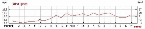
Saturday Windspeed
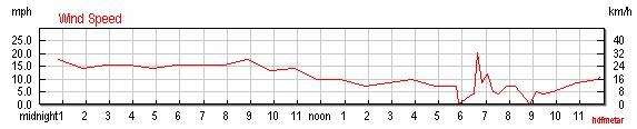
Sunday Windspeed
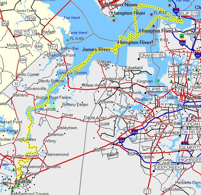
Our track
This page last updated on 1/29/2012 6:49:52 AM. If you have comments or suggestions, email me at webmaster@jscheetz.com